
Google Maps is a gamechanger to many people in how they commute. Along with Earth, Google update the two apps to use a imagery from the U.S. Geological Survey’s (USGS) Landsat 8 satellite. While this update doesn't make Maps and Earth more useful, it indeed makes them more beautiful to see.
With the update, the apps can now show true colors in more details, thanks to a new algorithm that searches through petabytes of imaging data.
Google first announced the news on in its Lat Long Blog for Maps on June 27th, 2016. It goes by saying that the update is its biggest one for both Maps and Earth since 2013's Landsat 7 imaging database crawl that eliminated clouds.
The 2013's update made photo imagery a lot better because it updates the relatively low-res data that came before it. But the Landsat 7's satellite imagery suffered a scan-line corrector failure.
Because the imagery was still the best available at the time, Google has no other choice than to come up with ways to remove those diagonal gaps of missing data. The company filled those empty spaces with interpolated data, which in turn lowered the overall image detail and quality.
This is where the June 2016's Landsat 8 update fixes the issue. The update progressively fix that for Google's satellite imagery around the world. The new data is being updated progressively to several regions in the world.
Besides the ability to capture images with greater details and better colors, the Landsat 8 can also capture images twice as often as the previous Landsat 7.
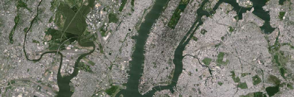
Below, is an imagery of New York City using Landsat 7.
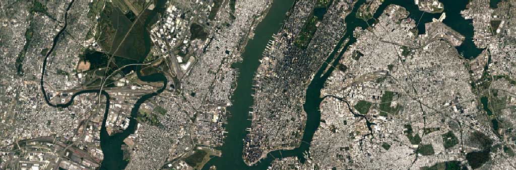
And here is New York with Landsat 8. We can see that the visuals appear more crisp and detailed. For example, the details on skyscrapers are now visible. Building shadows are present, and the baseball fields in Central Park are distinguishable.
As for the update explanation, Google said that the new mosaic was crafted from a nearly petabyte of data containing more than 700 trillion pixels. The Landsat 8's new imagery was made possible because Google collaborated with NASA, in which also collaborated with the United States Geological Survey. This makes the Landsat database open source for anyone to make use of.
Landsat has been in operation since 1972 to track changes to the Earth over time. All of the imagery can be accessed using the Earth Engine application programming interface, making its data more open and accessible.
For scientists, they have been using it to study large-scale global changes in the environment, one which is to track the spread of diseases.
But for Google, the company's approach is simpler, and that is to serve a map of the Earth from an orbiting satellite view. And with the Landsat 8, the view of Earth has never looked better.
To notice the change, you just need to enable the satellite terrain layer to see the new imagery. This feature is somehow not that popular to those people that use Google Maps to commute or find their way around. So the change won't be noticeable by average users. But to those people that spend more of their time in satellite view than otherwise, the update is indeed a welcome change.