
Smartphones are packed with a lot of sensors, and one of the most notable, is the GPS sensor.
With the novel 'COVID-19' coronavirus spreading as the pandemic widens, Apple wants to protect its users. And at the same time, Apple has billions of users, and this is also why it wants to benefit the society by helping authorities protect others too.
To make this happen, the Cupertino-based company is releasing what it calls he 'Mobility Trends' tool.
The tool is simply reports aggregated mobility data from Apple Maps, created to help public health officials better understand changes in how people are moving in their communities to help slow down the virus' spread.
The tool can reveal changes in the number of people driving, walking or taking public transits in 63 countries or regions.
According to Apple on its announcement:
While protecting your privacy, we are sharing aggregated mobility data from Apple Maps to help public health authorities learn how people travel in their communities and to provide valuable insights to stop the spread of COVID-19. Stay safe and healthy! https://t.co/Nok77HKIXN
— Tim Cook (@tim_cook) April 14, 2020
To make sure that users' privacy is respected, the data Apple collects to populate the report is not associated with any Apple ID. In other words, Apple is making the data anonymous and couldn't be traced back to the user.
To do this, the data Apple collects from Maps (such as traffic information, search terms and navigation routing), is paired with random identifiers that are always changing. This helps Maps users use the app like they normally would, while keeping their details secret.
Apple also said that it doesn't keep a history of where a user has been.
"The information is generated by counting the number of requests made to Apple Maps for directions. The data sets are then compared to reflect a change in volume of people driving, walking or taking public transit around the world. Data availability in a particular city, country, or region is subject to a number of factors, including minimum thresholds for direction requests made per day," explained Apple.
To see this Apple Maps Mobility Trends tool report, people can browse to https://www.apple.com/covid19/mobility.
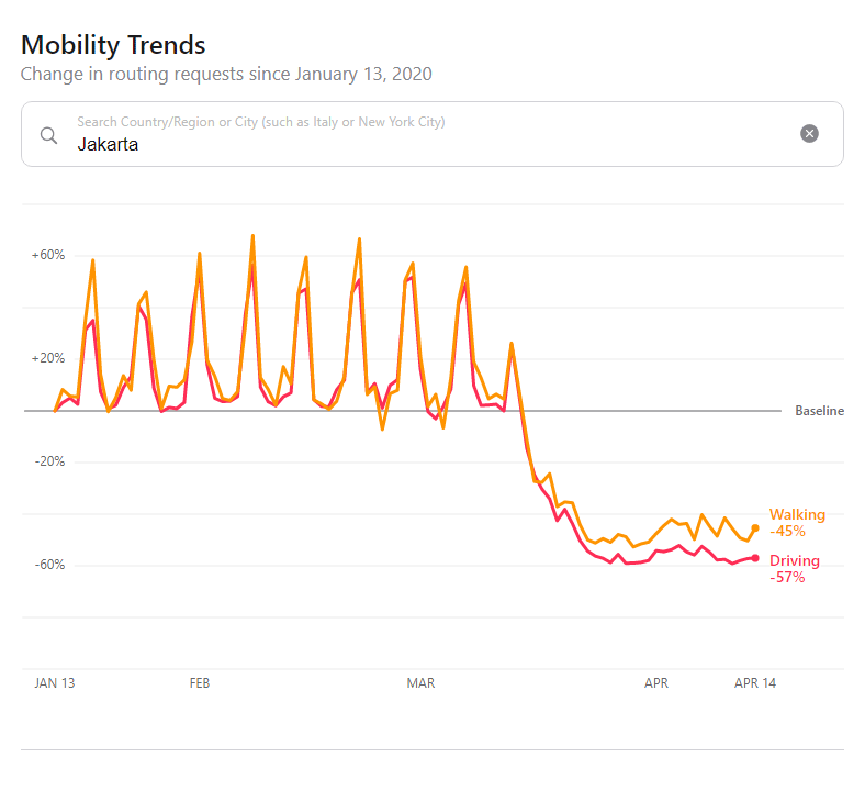
At the web page, users can type in certain countries, regions or cities, to see how people in that area have changed in how they go from one place to another during the coronavirus pandemic.
Searching for 'Jakarta' for example. the tool shows that activities of people in the Indonesia's capital city have dropped significantly since March 2020. Since April 14, thanks to the coronavirus, citizens of Jakarta are walking 45% less than usual, and driving is 57% less.
In Indonesia as a whole, driving and walking are down by 57% and 67%, respectively.
For countries, regions or cities that Maps have the public transportation feature available, the tool will include 'Transit' data.
For convenience, Apple is making the complete dataset available for download as a CSV.
Besides the Apple Maps Mobility Trends tool, Apple is also working together with Google to create a contact tracing tool.
The goal of this tool is allow users of iOS and Android to receive warnings when they were in close proximity to someone who has been tested positive for the coronavirus. With the contact tracing tool, users receiving the warnings can make sure that they are tested promptly, and can follow instructions from health officials.
With this particular partnership, the two companies have the potential to track 3 billion people around the world.
Putting privacy concerns aside, this tool can certainly help curb the spread of the virus.