

There is no doubt that people have needs. This is why there are still people who go out, even when their governments urge them to stay indoor during the coronavirus pandemic.
With coronavirus cases crossing the one million mark, countries around the world are taking even more strict actions to help curb the virus and contain those who are still moving about.
After previously launched a COVID-19 information website, Google releases anonymized data the company gathered from Maps users in 131 countries to the public, researchers, and governments.
Called the 'COVID-19 Community Mobility Reports', the initiative aims to help health officials understand how people are moving around.
On the website, Google said that:
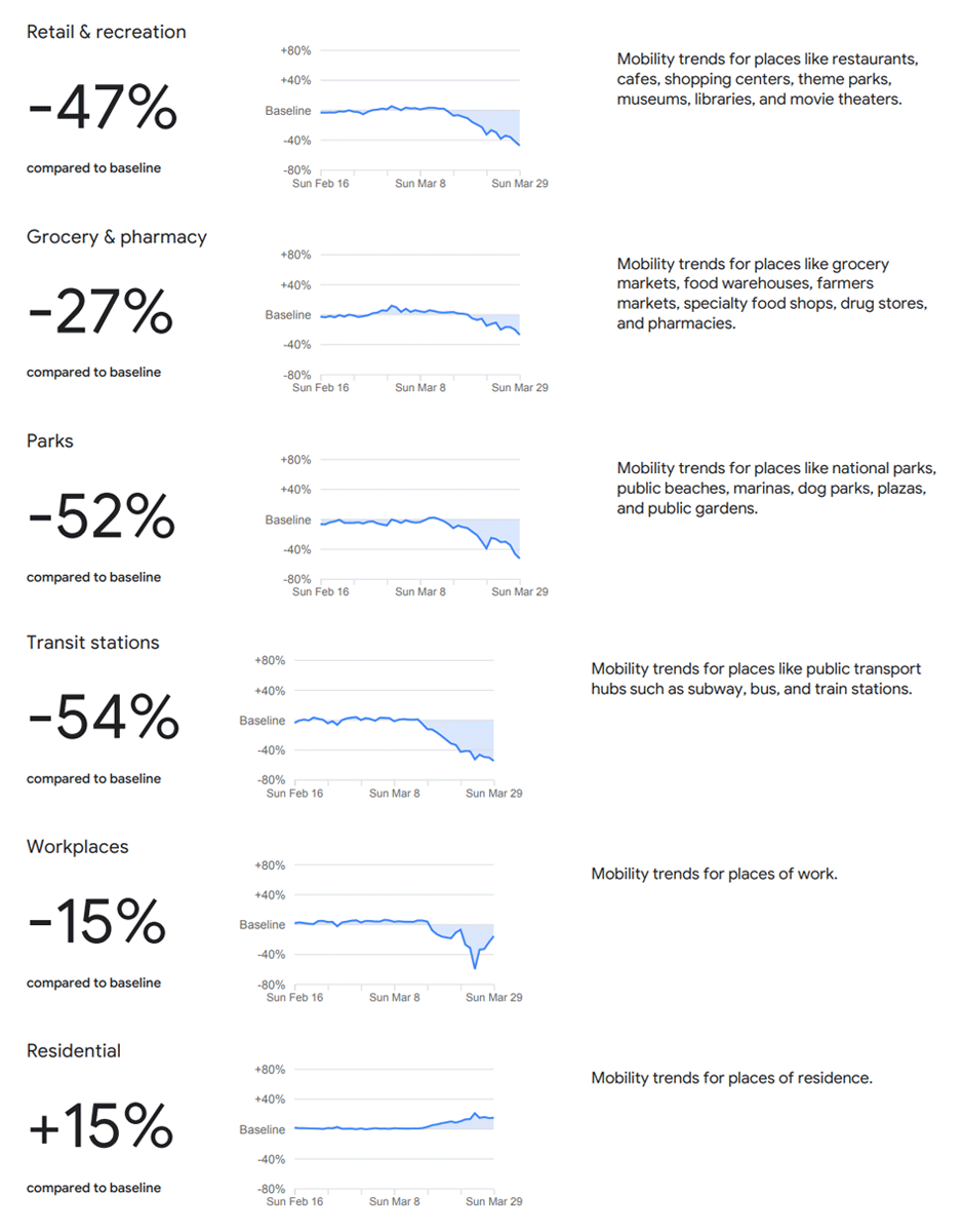
The reports contain trends of Google Maps users' movements, categorized into different sections:
- Retail & recreation: Mobility trends for places like restaurants, cafes, shopping centers, theme parks, museums, libraries, and movie theaters..
- Grocery & pharmacy: Mobility trends for places like grocery markets, food warehouses, farmers markets, specialty food shops, drug stores, and pharmacies.
- Parks: Mobility trends for places like national parks, public beaches, marinas, dog parks, plazas, and public gardens.
- Transit stations: Mobility trends for places like public transport hubs such as subway, bus, and train stations.
- Workplaces: Mobility trends for places of work.
- Residential: Mobility trends for places of residence.
The company said the reports contain data it gathered from the past several weeks up to the last 48 to 72 hours, from users who have turned on their location history in Google Maps.
Reports like these may help public health officials understand people’s habits when they go outside their homes, helping them support their decisions about how to manage this COVID-19 pandemic, like for example, helping them understand changes in essential trips that can shape recommendations on business hours or inform delivery service offerings.
This report however, shouldn’t be used for medical diagnostic, prognostic, or treatment purposes. It also isn’t intended to be used for guidance on personal travel plans.
The company added that data collected for these trends is anonymized and “no personally identifiable information will be made available at any point.”
A similar initiative, in a smaller scale, was made by some government around the world, including in Singapore with the 'TraceTogether' app, and Indonesia with the 'PeduliLindungi' app.
Read: Using 'TraceTogether' App To Curb Coronavirus' Spread: Indonesia Follows Singapore