Three years have passed since the morning of 7 October 2023, when Hamas and other armed groups broke through the border fence and attacked communities, military posts, and a music festival in southern Israel.
The attack opened a war that left a record of the fighting scattered across social media, Telegram channels, and journalists’ phones.
The Gaza Health Ministry, whose figures are widely cited by news organizations and aid agencies and which does not separate civilians from fighters in its headline total, reported roughly 74,000 people killed and about 175,000 injured in the Strip by early October 2026, including about 20,000 children. Israeli officials dispute parts of that accounting and have published their own estimates of people killed.
A ceasefire did not end the killing. The ministry has continued to record deaths in the months that followed. Satellite analysis by the UN's UNOSAT unit, based on imagery through 11 October 2025, found about 198,000 structures damaged or destroyed, roughly 81% of the building stock it assessed.
That physical record is also a digital one, and it has been harder to check than the volume of footage suggests.
From the first days of the war, videos of strikes, rescue attempts, bodies, and destroyed streets circulated online faster than any newsroom could check them.
Open-source researchers responded with geolocation: matching a minaret, a road junction, a shadow, or a damaged block in a clip to satellite imagery and older maps, then publishing the match so others could test it.
GeoConfirmed, a volunteer project that had already mapped footage from Ukraine, put up an interactive map of verified clips within weeks of 7 October 2023.
Later projects, including Genocide Live and smaller Gaza-focused maps, kept adding pins.
The method does not decide who fired or whether a strike was lawful. It answers a narrower question: where, and roughly when, a piece of footage appears to have been filmed.
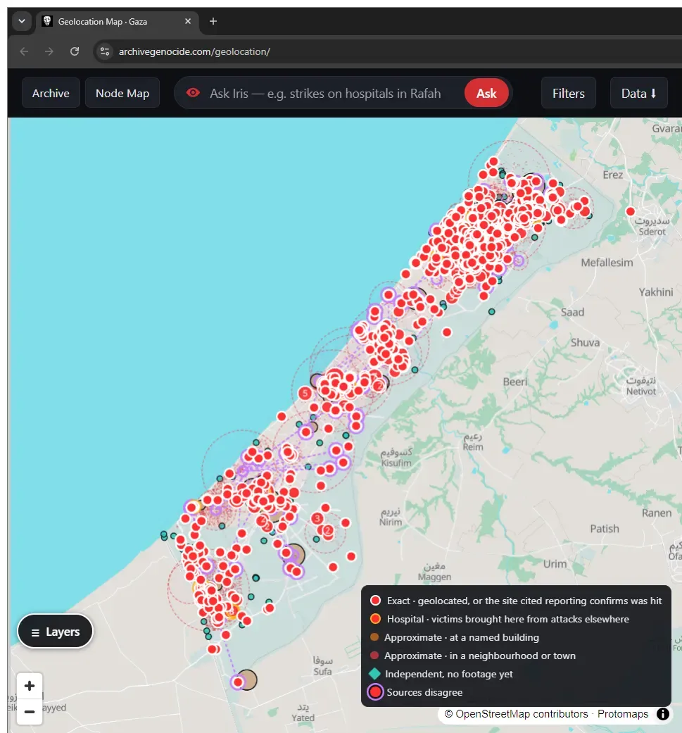
Archive Genocide, the project behind the account Israel Exposed, spent the intervening years collecting that material into a single archive and, in October 2026, finished a public geolocation map of the clips whose locations it says it knows.
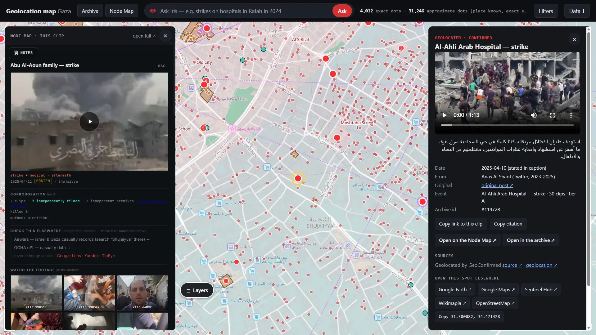
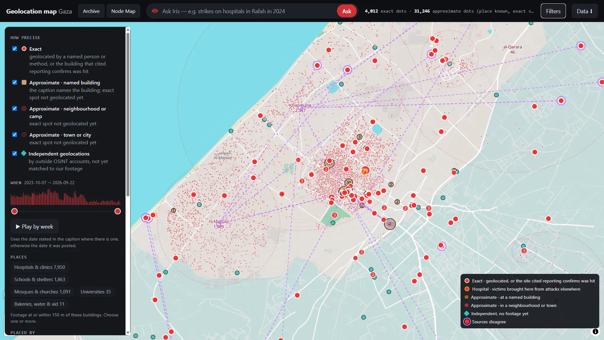
The group says the map holds more than 35,200 videos and photos, each tied to a source and the original post, with filters for area, date, type of incident, and how precise the pin is.
Some points are marked exact. Others are only as specific as a neighborhood, a camp, or a named building.
An assistant called Iris can narrow the map by place or query.
A layer drawn from the UNOSAT survey shows the satellite damage assessment beside the footage pins.
The dataset can be downloaded as CSV, GeoJSON, or a Google Earth file.
The project credits outside geolocators, including GeoConfirmed, Abu Location, and NemoAnno, and says it will keep adding clips as researchers work through the rest of the archive.
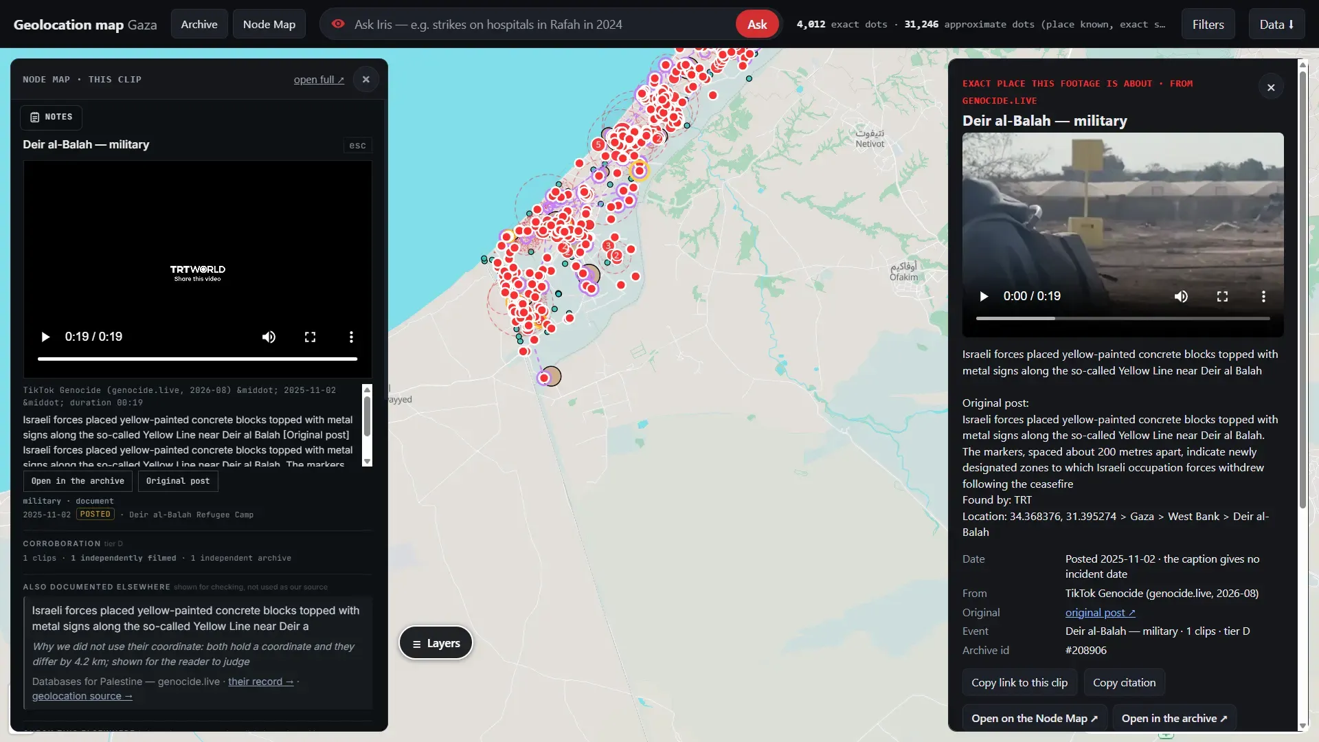
The footage itself comes from the internet: journalists and photographers who posted from Gaza, Telegram channels, Instagram accounts, and existing collections that the site lists among its sources.
The organizers describe the material as documentation of Israeli attacks and say the full raw volumes, measured in terabytes, are mirrored for download.
On the site, clips are grouped by signals that can be checked, such as a matching video fingerprint or the same original post, and links between events are graded so that a weak lead is not presented as a confirmed match.
Users can open a node, follow the source, and run a reverse-image search. That design is meant to make an internet archive usable as a map rather than a folder of files.
A pin is still only as strong as the clip and the match behind it.
Social-media video can be re-edited, misdated, or filmed at a distance that supports a neighborhood but not a building.
Archive Genocide's own precision filters are an admission of that limit, and the project is explicit that it draws on prior geolocation work rather than claiming to have verified every event from scratch.
For researchers, the useful part is the combination of a large set of located clips, the original posts, and a file that can be opened outside the site and compared with satellite damage data and other maps.
Three years after the October attack, the war's casualties are still counted in competing ledgers, and much of the footage was recorded because outside reporters could not go and see for themselves.
The map does not settle those counts. It tries to put a share of the footage that circulated online back onto the ground where it was filmed.
Further reading: Angelina Jolie Shows Gaza’s Destruction on Instagram as Millions Take Notice While Google Remains Quiet
It's worth noting that since 7 October 2023, Israel has barred foreign journalists from entering Gaza on their own.
The Foreign Press Association challenged the ban in the Israeli Supreme Court, with the Committee to Protect Journalists filing in support. The state's position, restated into 2026, is that unescorted entry is too dangerous.
Access has been limited to short, military-escorted trips on routes the army chooses.
Reporters on those trips cannot move freely or interview people outside the escort, and the restriction stayed in place through an earlier pause in fighting and after the October 2025 ceasefire announcement.
Inside Israel, the military censor still requires prior review of security-related reporting. Palestinian journalists inside Gaza have been the main source of footage. The Committee to Protect Journalists says Israeli forces have killed more journalists and media workers since 2023 than any other government in its records, with the large majority of those deaths in Gaza.
Israel says many of those killed were combatants or were hit in strikes on military targets. Independent investigators have not been able to enter freely to test either account case by case.
Online, the filter continued.
A 2025 Drop Site report based on internal Meta data said Israel was the largest source of government takedown requests after 7 October 2023, that Meta complied with about 94 percent of them, and that more than 90,000 posts were removed, mostly under terrorism or violence rules and mostly from users in Arab and Muslim-majority countries.
Platforms also remove content for other reasons.
TikTok said it took down millions of videos in the region for Hamas support, hate speech, and misinformation, and it has removed Israeli material as well.
Separately, the IDF has tightened rules on soldiers filming in operational areas and built a system to flag public posts that expose bases, weapons, or misconduct.
Commanders frame that as operational security. The practical effect is that some of the clearest primary video of what troops do in Gaza comes from soldiers' own phones, and the army tries to get those posts taken down.
Hamas has its own controls on what Gazans can say. Footage still leaves the Strip. It leaves through a narrower gate.
And attempts like Archive Genocide wants to make sure that everything is documented, searchable, and available to anyone who wishes to witness what Israel is trying to justify.
Further reading: Israel is Found Paying Millions of Dollars to Shape What AI Tells Americans About Gaza, While the Sponsors Stayed Unseen at the Bottom of the Page